Jomsom Airport – The Aerial Gateway to Mustang and the Himalayas
Introduction
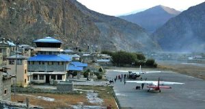
Jomsom Airport is a remote yet strategically vital domestic airport located in Jomsom, the administrative center of the Mustang District, Nepal. Positioned at an elevation of around 2,700 meters (8,859 feet), this airport lies in the rain-shadow region of the Annapurna and Dhaulagiri mountains, making it a rare all-season destination in the high Himalayas.
Despite its short runway and weather-related challenges, Jomsom Airport plays a pivotal role in connecting the mountainous northern region of Nepal with the rest of the country—especially the city of Pokhara, the nearest major hub.
Geographic and Strategic Importance
Location
-
Coordinates: 28°46′58″N 83°43′46″E
-
Province: Gandaki Province
-
District: Mustang
-
Accessibility: About 20 minutes by air from Pokhara, or 10–12 hours by rugged road travel.
Strategic Role
-
Tourism Gateway: It serves as the main entry point for trekkers on the Annapurna Circuit, Jomsom-Muktinath Trek, and Upper Mustang Trek.
-
Pilgrimage Route: Acts as a transit hub for pilgrims heading to Muktinath Temple, one of the most sacred Hindu and Buddhist pilgrimage sites.
-
Lifeline for Locals: Facilitates the supply of goods, emergency medical evacuations, and government services to isolated communities in Mustang.
Airport Specifications
| Feature | Detail |
|---|---|
| IATA Code | JMO |
| ICAO Code | VNJS |
| Type | Public, Domestic |
| Operator | Civil Aviation Authority of Nepal |
| Runway Surface | Asphalt |
| Runway Length | 739 meters (2,425 feet) |
| Elevation | 2,700 meters (8,859 feet) |
Due to its high altitude and mountainous location, Jomsom Airport is classified as a STOL (Short Takeoff and Landing) airport. Aircraft like the DHC-6 Twin Otter and Dornier 228 are most commonly used.
Flight Operations and Safety Concerns
Common Flight Routes
-
Pokhara to Jomsom: The main commercial route, with flight times of 20–25 minutes.
-
Charter Flights: Available from Kathmandu via Pokhara, mostly for tourists or emergencies.
Operational Challenges
-
Mountain Weather: Flights are highly susceptible to sudden changes in weather, with strong valley winds and cloud cover often grounding planes.
-
Time Limitations: Most flights are conducted early in the morning, typically before 11:00 AM, when weather is relatively stable.
-
Visual Flight Rules (VFR): Only daytime flights are permitted under clear weather, as there are no instrument landing systems (ILS).
Safety Record
While the airport is safe under optimal conditions, there have been several minor and a few serious incidents, mostly due to unpredictable wind shear or visibility problems. The terrain requires highly experienced pilots familiar with Nepal’s mountainous airstrips.
Tourism and Cultural Relevance
Popular Attractions Accessible from Jomsom
-
-
Sacred to both Hindus and Buddhists
-
Located about 20 km northeast of Jomsom
-
Elevation: ~3,710 meters (12,172 feet)
-
-
Kagbeni Village
-
Gateway to Upper Mustang
-
Ancient Tibetan-style village on the banks of the Kali Gandaki River
-
-
Kali Gandaki Gorge
-
One of the deepest gorges in the world
-
Carved between the Annapurna and Dhaulagiri ranges
-
-
Marpha Village
-
Known for apple orchards and traditional stone architecture
-
Located a short drive or trek south of Jomsom
-
Treks Starting from Jomsom
-
Jomsom to Muktinath Trek (2–3 days)
-
Upper Mustang Trek (restricted area – permit required)
-
Jomsom to Marpha and Tatopani (hot springs trail)
-
Portion of the Annapurna Circuit
Economic and Social Impact
For Locals
-
Reduces dependence on long, dangerous road travel
-
Improves access to education, healthcare, and trade
-
Facilitates faster disaster response and evacuations
For Tourism
-
Drives significant revenue from trekking permits, lodges, and transportation services
-
Supports sustainable tourism in a fragile Himalayan ecosystem
-
Encourages cultural exchange in a historically restricted area
Trivia and Noteworthy Facts
-
Jomsom Airport is one of the highest airports in Nepal, after Lukla and Simikot.
-
It is often included in lists of the world’s most dangerous airports due to weather volatility and terrain.
-
The area is rich in fossils called “Shaligrams,” which are sacred to Hindus and found in the Kali Gandaki riverbed.
-
Jomsom was once a key trading post on the ancient Trans-Himalayan salt trade route between Tibet and Nepal.
Conclusion
Jomsom Airport is more than just an airstrip—it’s a gateway to adventure, spirituality, and survival in the high Himalayas. Whether you’re a trekker heading for Annapurna, a pilgrim en route to Muktinath, or a cultural explorer seeking the mysteries of Mustang, this small but significant airport is your entry point.
Its operational limitations are balanced by its critical role in connecting Nepal’s remote Himalayan communities, making it one of the country’s most important domestic airports.